news | upcoming


..Georgie Friedman of Boston, meanwhile, pursues visual qualities that are precisely the opposite of Google Earth’s drive toward ever-increasing clarity and precision...
press:
The Boston Globe
October 13, 2010
By Sebastian Smee, Globe Staff

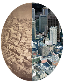
James Wallace Black took the first aerial photo of Boston in 1860, left, which is shown next to a Google Earth image of Boston on Oct. 12, 2010.
CRITIC’S NOTEBOOK
One hundred and fifty years ago today, James Wallace Black went up 1,200 feet in a balloon over Boston and took the first successful aerial photograph in the United States.
From the perspective of late 2010, when aerial and satellite imagery has transformed everything from waging war to avoiding traffic congestion on morning commutes, Black’s balloon trip looks nothing short of momentous.
Our relationship with the world has been transformed by aerial photography. The changes have accelerated dramatically over the past decade, when photographs from planes and satellites have merged with the potential unleashed by faster computers, widespread broadband, and 3-D digital graphics to get us closer to what Google Earth product manager Peter Birch describes as the ultimate aim: an ability to “recreate the real world in a virtual world.’’
Black, who was born in Boston and is buried in Mount Auburn Cemetery, took some of the best-known portraits in the early days of American photography and helped develop the magic lantern, a candlelight-powered projector.
But he wasn’t the first person to take aerial photographs from a balloon. Nadar, as the Frenchman Gaspard-Félix Tournachon called himself, managed that feat two years before Black. But Nadar, whose balloon trips over Paris made him an international celebrity and inspired Jules Verne, did not initially make photographs that lasted.
Black was luckier — although only one of the eight 10-by-8-inch glass negatives he exposed on that Oct. 13, 1860, balloon trip produced a clear, stable image. He called it “Boston, as the Eagle and the Wild Goose See It.’’ Today it is in the Boston Public Library.
An 1862 caricature by Honoré Daumier shows Nadar precariously perched in the basket of his balloon, peering into his camera as his top hat flies off his head. “Elevating photography to the level of art,’’ says the caption.
But over the years, scientists, corporations, and the military have all exploited the possibilities of aerial imagery more aggressively than artists.
Today, Geographic Information Systems, or GIS, which uses mapping software to combine aerial photography, maps, and geographical data, is used for everything from mining exploration to environmental preservation, epidemic planning, disaster response, and humanitarian relief.
Since its founding by billionaire Jack Dangermond in 1969, Environmental Systems Research Institute, or ESRI, has led the way in exploiting the potential of these emerging technologies.
Federal governments have relied on ESRI’s software when responding to catastrophes such as the BP oil spill, just as city officials use it to allow residents to text information about potholes, graffiti, and trash in their neighborhoods.
Google Maps and Google Earth have democratized the use of aerial photography, making it possible for everyone with a computer to zoom in their house from space, shifting from a bird’s-eye to a street level view with the click of a mouse.
To mapping specialists, Google Earth can seem to amount to not much more than “pretty pictures.’’ But the potential unleashed by its very ubiquity is vast.
Clarity and precision have become the ultimate goals in the quest to increase the appeal and usefulness of GIS technology. Today, according to Birch, the entire surface of the earth has been photographed from satellites at a degree of resolution equal to about 15 meters per pixel. That’s pretty fuzzy.
But 30 percent of the earth’s landmass and about half of its population is covered by imagery that shows less than 60 centimeters per pixel.
And many other areas, particularly urban ones, have been photographed from the air rather than space, producing higher resolutions of about 15 centimeters per pixel.
When you combine this with modeling software, which Google has made freely available, it’s possible to make the transition from aerial photography to convincing 3-D imagery. And that is what hundreds of thousands of Google Earth users have already done.
Google is constantly updating its imagery. But instead of discarding old images, it has introduced a function that incorporates out-of-date and historical photographs, enabling users to peel back layers of time. As a result, you can see what Boston looked like before and after the Big Dig, and even what Dresden looked like after the 1945 firebombing.
What happened to art in all this? Has Daumier’s caricature of Nadar “elevating photography to the status of art’’ been entirely superseded?
Not at all.
Photographers have used the aesthetic potential of the bird’s-eye view for more than a hundred years. Perhaps none of them has been as great as California’s William Garnett, whose black-and-white photographs of land forms and waterways seen in raking light were taken from a 1955 Cessna 170.
More recently, activist artists such as J. Henry Fair have taken photographs of polluted environments from the air. Fair’s work chimes with the work done by government agencies and environmental groups, who use aerial imagery to make polluters accountable for their actions.
Georgie Friedman of Boston, meanwhile, pursues visual qualities that are precisely the opposite of Google Earth’s drive toward ever-increasing clarity and precision.
Collaborating with engineers Justin Hamel and Chris Thompson, Friedman has been sending video cameras up in unmanned balloons that go to the upper limits of the earth’s atmosphere, before bursting and falling back to earth. The camera records both video and still images taken at regular intervals. (Friedman will display both in the windows of two Boston galleries, Carroll and Sons and Anthony Greaney, Jan/Feb 2011.)
“I am less interested in the clarity of images,’’ Friedman says, “[than in] unpredictable and uncontrolled occurrences.’’
Her photographs show the subtle color shifts of clouds and sky as the balloon ascends. After it bursts, the camera spins and tumbles, capturing distant horizons as well as the flapping remnants of the balloon in what Friedman calls “the chaotic imagery of the uncontrolled free-fall.’’
Unlike the technicians at Google Earth and ESRI, who seem preoccupied with the goal of achieving a kind of visual and hence conceptual mastery over nature, Friedman relishes the lack of control over her imagery, and the resonances — both mythological and psychological — of “crashing back down to earth.’’
Which vision of our world, one wonders, will win out? Google Earth’s real world fastidiously recreated as a video game-like virtual world? Or Friedman’s “uncontrolled free-fall’’?
all images, video and other content © georgie friedman